Round Australia Road Trip #21
When the explorer Edward John Eyre completed his crossing of the Nullarbor Plain in 1841, he described it as “a hideous anomaly, a blot on the face of Nature, the sort of place one gets into in bad dreams”. Perhaps his opinion was coloured by his experiences. Three of his horses died of dehydration, his expedition partner John Baxter was murdered by two Aborigines and the rest of the party took seven months to complete the crossing from east to west.
Travelling by car when crossing the Nullarbor makes the journey faster and easier; it’s an iconic adventure and, despite Eyre’s lack of enthusiasm, there is plenty to see along the way.

The west to east crossing of the Nullarbor Plain, the world’s largest area of limestone bedrock, begins at Norseman in Western Australia and ends at Ceduna in South Australia. The word Nullarbor is derived from the Latin words nullus meaning no and arbor meaning tree and, although the first section is covered by eucalypt forest, saltbush and bluebush scrub dominate the land for much of the journey. The plain extends over an area of 200 000 square kilometres and the actual treeless part is more than a day’s drive from Norseman.

Crossing the Nullarbor by car means travelling 1200 km on the Eyre Highway, named for Edward John Eyre who was the first European to cross the plain. There are no real towns between Norseman and Ceduna; isolated roadhouses separated by hundreds of kilometres supply fuel, basic supplies, and camping. Water availability is limited and travellers need to ensure they are carrying plenty.
100 km east of Norseman is Fraser Range Station, once a working sheep station and now a campground. The granite hills of Fraser Range rise up out of the Great Western Woodlands, the world’s largest hardwood eucalypt forest.

A further 90 km east at the Cultural Heritage Museum at Balladonia Hotel/Motel and Roadhouse, there are interactive displays about the history of the area, from the indigenous peoples to the pioneers and cameleers who first settled in the area. One fascinating exhibit details the crash landing of Skylab. Debris from the NASA spacecraft fell to Earth near Balladonia in July 1979.

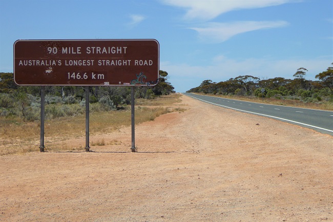
A little further east is the beginning of the longest straight stretch of road in Australia – 146 km of black bitumen lined by mallee scrub and not a bend in sight.

The limestone karst of the Nullarbor Plain is littered with underground caves. Because of their fragility and concerns about visitor safety, most of the caves aren’t open to the public. Just before the next roadhouse at Caiguna is a blowhole, the entrance to a subterranean cave system which extends more than 20 km to the coast. Air chilled by the ocean is drawn through the caves until it makes its escape through these holes in the limestone. The breeze coming out of the blowhole is cool and refreshing. In the heat of the desert, Mother Nature’s air conditioning system is much appreciated.

According to the sign at Caiguna Roadhouse, this remote outpost on the highway is the hub of the universe!


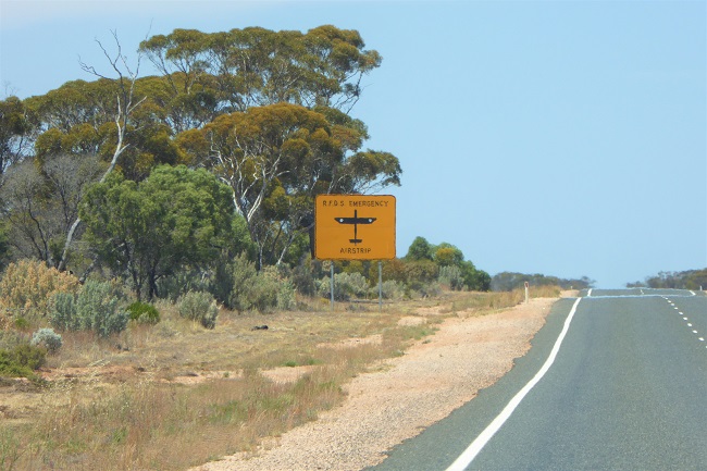
Occasionally the highway doubles as an emergency airstrip when the Royal Flying Doctor needs to land. The landing zone is clearly marked and if there is going to be an emergency landing the road is temporarily closed beforehand. The cleared spaces on either side of the highway are turning bays for the aircraft.

Just before Madura, there’s a sudden change in the landscape. A lookout at Madura Pass reveals the flat expanse of the Roe Plains which lie between the escarpment of the Hampton Tablelands and the cliffs of the Great Australian Bight. After descending through the pass, the highway tracks the ancient cliffs of the tablelands for 180 km between Madura and Eucla.


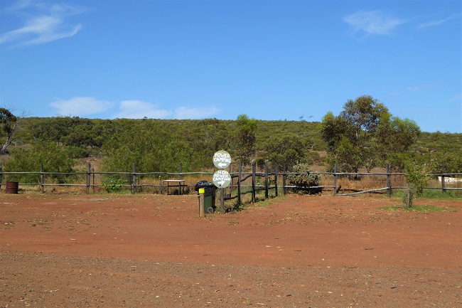
There are free camps on the side of the highway for truckies and for travellers. At the end of day one we stop at Moodini Bluff Rest Area for the night.

I am so so envious
LikeLiked by 1 person
It’s quite a trek but well worth the effort.
LikeLike
deffo bucket list
LikeLiked by 1 person
Glad you’re taking us on journeys we’d love to go on but may never get to…
LikeLiked by 1 person
I’m enjoying sharing it with everyone. It was an amazing adventure.
LikeLiked by 1 person
yeah…having three of your horses die, and spending 7 months crossing…that would darken your view of things. But I’ve wanted to do that trip by train for a long time.
LikeLike
It probably didn’t help that he did it in summer, when the temperature can reach 40 degrees C. I would love to do the train trip too. It goes much further inland than the highway.
LikeLike
I’ve lived in one desert or another for the past….hmmm, 30 years…so I’m used to 40 degrees…though, I don’t like being out in it that much! one reason why the train ride would be a little better…for comfort, if not freedom to stop and gander
LikeLiked by 1 person
It would be pretty amazing to do though.
LikeLike
agree!!!
LikeLike
Our country really is so vast and magnificent!
LikeLiked by 1 person
Yes, and even when we know that, the vastness is still astounding when you stand at the top of the pass and see the plain like that.
LikeLike
Fascinating. I have always wanted to do that trip. I bet it is tempting to drive fast on that straight road but I suspect there are speed cameras!
LikeLiked by 1 person
The speed limit is 110 km ph anyway, and I don’t think there are speed cameras. We didn’t see anyone going really fast but I bet some people give into temptation.
LikeLiked by 1 person
I completely agree with you that there’s obviously loads to see along this stretch of highway. Your photos make me want to jump into them and drive away! It fascinates me to think that through such an ancient piece of the earth, a few feet of bitumen is often the only trace of any human activity. Looking forward to the next leg 🙂
LikeLiked by 1 person
Believe it or not, there are actually properties here and people are still farming cattle. It must be tough going though.
There are places we didn’t even get to because, although we have a 4 wheel drive vehicle, our caravan isn’t off road so we couldn’t take it down the dirt tracks. So there is still lots we could do if we wanted to go again.
LikeLiked by 1 person
It’s amazing – everything is just so VAST! I cannot imagine driving along a straight road for 90 miles – it must be quite mesmerising.
LikeLiked by 1 person
I drove that part of the highway. It was great. I just sat there and went straight ahead. And not one other vehicle was going our way at the same time. I was wishing at the end I had counted the vehicles that went past in the other direction. I’d say not more than 20 in nearly two hours.
LikeLike
I can imagine I might need to do a lot of singing aloud to keep myself going. What a quiet road!
LikeLiked by 1 person
We had downloaded audio e-books from our local library so we listened to them along the way.
LikeLike
Oh yes, that’s a good plan. I’ve sometimes done that for long journeys too – the time passes very quickly that way.
LikeLike
I’ve never done the trip, but my neighbour does it twice a year. She’s very adventurous! I love the airstrip on the road. Have a great drive! 😀
LikeLike
My goodness, she’s keen.
LikeLiked by 1 person
Driving across the Nullarbor has always had something of a dangerous sound to it. It’s not something I’ve ever attempted (or likely to) so I’m very happy to come along for the vicarious ride.
LikeLiked by 1 person
I think it may have been more adventurous before the road was sealed. The only real danger now would be if you ran out of water or hit a camel! I’m glad you’re enjoying the ride.
LikeLiked by 1 person
Waw! 🙂 Cool!
LikeLiked by 1 person
Love these posts. We took the Indian Pacific Railway. Similar, but enjoy your account and photos from the road. Thanks for sharing
LikeLiked by 1 person
I was expecting to see the Indian Pacific go past until I checked the map and found that the train line was a good 100 km north of the highway for most of the crossing. I would like to do the train trip one day.
LikeLike